| |
 |
Informations
Intensités internet
Intensités définitives
Historique
Intensités macrosismiques préliminaires et informations
Séisme W de Marennes, (dept. 17,le 26/02/12 à 04h48 heure fr, magnitude 3.8) selon LDG
Date (en temps universel) : 26/02/2012
Heure (en temps universel) : 03h48
Magnitude : 3.8
Coordonnées :
Latitude : 45.85°N Longitude : 1.42°W
Aucune enquête en cours.
Carte d'intensités internet issue de 112 témoignages
(Date de création : 13/06/2026 14:24 T.U. )
Le temps sur cette page est donné en temps universel (TU) ; pour obtenir le temps local français
- Métropole ajouter + 1h l'hiver, + 2h l'été
- Guadeloupe et Martinique - 4h / Guyane : - 3h / Réunion : + 4h / Mayotte +3h
Séisme W de Marennes, (dept. 17,le 26/02/12 à 04h48 heure fr, magnitude 3.8) selon LDG | Dept. | Commune | Nb. Témoignages | Nb. Témoignages validés | Distance epicentre | ND*
| Int.:
1 | Int.:
2 | Int.:
3 | Int.:
4 | Int.:
5 | IPC*
|
|---|
| 17 | LA ROCHELLE | 23 | 23 | 40.26 km | 2 | 1 | 14 | 6 | | | 2 | | 17 | SAINT-GEORGES-DE-DIDONNE | 1 | 1 | 42.1 km | | | | | 1 | | 4 | | 17 | L'HOUMEAU | 1 | 1 | 41.74 km | | | | | 1 | | 4 | | 17 | NIEUL-SUR-MER | 1 | 1 | 44.75 km | | | 1 | | | | 2 | | 17 | SAINT-XANDRE | 3 | 3 | 46.06 km | 1 | | 2 | | | | 2 | | 17 | DOMPIERRE-SUR-MER | 1 | 1 | 46.89 km | | | 1 | | | | 2 | | 17 | PERIGNY | 2 | 2 | 41.49 km | 1 | | | 1 | | | 3 | | 17 | SAINT-GEORGES-D'OLERON | 9 | 9 | 16.03 km | 1 | | 2 | 6 | | | 3 | | 17 | ROYAN | 1 | 1 | 38.89 km | | | | | 1 | | 4 | | 17 | CLAVETTE | 1 | 1 | 44.1 km | | | 1 | | | | 2 | | 17 | CROIX-CHAPEAU | 1 | 1 | 42.86 km | | | 1 | | | | 2 | | 17 | LA JARNE | 1 | 1 | 41.2 km | | | 1 | | | | 2 | | 17 | LA JARRIE | 3 | 3 | 44.38 km | | | 3 | | | | 2 | | 17 | SAINT-CHRISTOPHE | 1 | 1 | 49.26 km | 1 | | | | | | 0 | | 17 | SAINTE-SOULLE | 1 | 1 | 49.27 km | | 1 | | | | | 1 | | 17 | SALLES-SUR-MER | 2 | 2 | 39.3 km | | | 1 | 1 | | | 3 | | 17 | CIRE-D'AUNIS | 2 | 2 | 44.46 km | | | 2 | | | | 2 | | 17 | SAINT-PIERRE-D'OLERON | 14 | 14 | 13.99 km | 2 | 1 | 3 | 5 | 2 | 1 | 3 | | 17 | MARENNES | 2 | 2 | 24.23 km | 1 | | | 1 | | | 3 | | 17 | CHATELAILLON-PLAGE | 2 | 2 | 35.31 km | | | | 2 | | | 3 | | 17 | YVES | 1 | 1 | 34.27 km | | | 1 | | | | 2 | | 17 | SAINT-TROJAN-LES-BAINS | 5 | 5 | 16.29 km | | | 2 | 3 | | | 3 | | 17 | ANNEZAY | 2 | 2 | 57.68 km | | 2 | | | | | 1 | | 17 | LA TREMBLADE | 6 | 6 | 22.72 km | 1 | | | 5 | | | 3 | | 17 | SAINT-MARTIN-DE-RE | 4 | 4 | 39.08 km | 1 | | 2 | 1 | | | 2 | | 17 | SAINT-PALAIS-SUR-MER | 1 | 1 | 34.63 km | | | | 1 | | | 3 | | 17 | AYTRE | 2 | 2 | 39.25 km | 1 | | 1 | | | | 2 | | 17 | FOURAS | 2 | 2 | 29.88 km | | | | 2 | | | 3 | | 17 | SAINT-LAURENT-DE-LA-PREE | 1 | 1 | 32.73 km | | | | 1 | | | 3 | | 17 | LE CHATEAU-D'OLERON | 4 | 4 | 17.59 km | | | 1 | 3 | | | 3 | | 17 | ARVERT | 2 | 2 | 25.57 km | 1 | | 1 | | | | 2 | | 17 | ANAIS | 1 | 1 | 54.55 km | | | 1 | | | | 2 | | 17 | VERINES | 1 | 1 | 51.31 km | | | 1 | | | | 2 | | 17 | DOLUS-D'OLERON | 2 | 2 | 14.06 km | 1 | | 1 | | | | 2 | | 17 | BOURCEFRANC-LE-CHAPUS | 2 | 2 | 21.67 km | | 1 | | 1 | | | 2 | | 17 | LES MATHES | 3 | 3 | 25.42 km | 1 | | 1 | 1 | | | 3 | | 17 | BEAUGEAY | 1 | 1 | 33.44 km | | | | 1 | | | 3 | | 17 | LA FLOTTE | 2 | 2 | 38.41 km | | | 2 | | | | 2 | | 17 | SAINT-DENIS-D'OLERON | 1 | 1 | 20.24 km | | | | 1 | | | 3 | | 17 | ANGOULINS | 1 | 1 | 37.52 km | | | 1 | | | | 2 | | 17 | PORT-DES-BARQUES | 1 | 1 | 28.54 km | 1 | | | | | | 0 | | 17 | SAINTE-MARIE-DE-RE | 4 | 4 | 34.4 km | | | 3 | 1 | | | 2 | | 17 | ETAULES | 2 | 2 | 28.15 km | | | | 2 | | | 3 | | 17 | MOEZE | 1 | 1 | 30.14 km | 1 | | | | | | 0 | | 17 | LES PORTES-EN-RE | 1 | 1 | 44.87 km | | | 1 | | | | 2 | | 17 | BREUILLET | 1 | 1 | 33.74 km | | | | | 1 | | 4 | | 17 | RIVEDOUX-PLAGE | 3 | 3 | 36.1 km | | | 3 | | | | 2 |
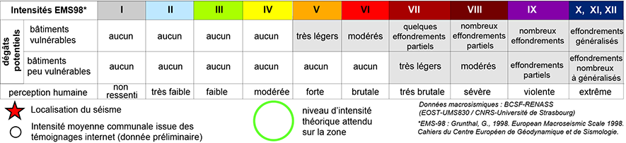
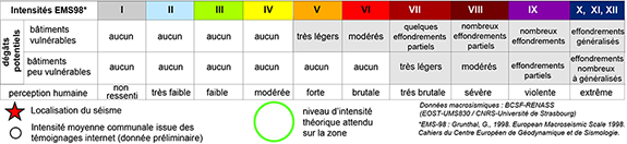
ND*: non défini - IPC*: Intensité préliminaire communale
|
Intensités macrosismiques issues de l'analyse de l'ensemble des informations collectées:
formulaires collectifs, formulaires individuels, enquête des témoins, informations complémentaires
Données en cours de collecte et d'analyse
Séismes historiques d'intensité épicentrale supérieure à VII dans un rayon de 80 km autour de l'épicentre.
Pas de séisme historique dans la région
D'après les données BRGM, EDF, IRSN / SisFrance, plus d'information sur www.sisfrance.net
|
|